
When you get the updated NHC report on “your” tropical disturbance, you’re usually hoping for some change – a new forecasted path that takes it farther away from you, or a downgrade in the winds, or the rare and beautiful “it’s just going to fizzle out” forecast. You’ve waited 6 long hours since the last update – you want an UPDATE! But the 2:00 p.m. update yesterday gave no such satisfaction. The image was virtually the same as 6 hours before. (See below.)
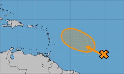
And the forecaster’s comments? The same as six hours ago. C’mon, Forecasters Zelinsky and Ramos, did you just phone this one in? We want your CURRENT assessment of the situation – not what someone else thought about it six whole hours ago! I pay good money for these forecasts – put some effort into them, people! (Oh wait… they’re free. But still!)
Six Hours Later: Be careful what you wish for – when the 8:00 p.m. update came out, the image changed, and not necessarily for the better. This is the first time this disturbance is showing actually impacting the Leeward Islands (the northern part of the Caribbean island chain, where St. Martin – and Smartini – is). It’s been pointing that direction all along, but that orange line touching St. Martin somehow makes it more real.
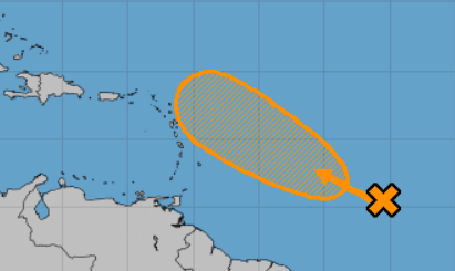
The forecaster’s comments remain ambiguous: Although upper-level winds
are expected to be only marginally conducive for development, this system could become a tropical depression early next week while it moves west-northwestward toward the Leeward Islands. “Marginally conducive” and “could become” – not the kind of language they teach you in Toastmasters – too wishy-washy. But I’d rather have wishy-washy than “IT’S HEADING RIGHT FOR YOU, FOR SURE, AND IT’S GONNA BE NASTY!” Now, if all it does is becomes a Tropical Depression, that just means above normal wind and rain while it blows through, probably for 12 – 24 hours. We can handle that, especially if we’re in a marina that’s in a lagoon, which is where we’re going to be.
Of course, there are those who aren’t as trusting of our NOAA forecasters, who are advising we make a run for Grenada while we still can. And, in all seriousness, it’s those bits of advice that add to the stress of any tropical weather heading our way. They’re not bad advice at all – in fact, they’re probably the safest advice. But, had we left for Grenada yesterday (Friday), giving us plenty of time to get out in front of it, we might have had one nasty day on the water. Because winds yesterday afternoon were TWO TIMES what they were forecast, and we had all we wanted of it in the hour and fifteen minutes it took us to relocate from the French side of the island (Marigot Bay) to the Dutch side (Simpson Bay), where we have to be to get into the lagoon. If we had been heading south in the open seas when that hit, it could have made for a very, very unhappy crew of Smartini for several hours.
The bottom line is that we’ve decided to be in St. Martin this hurricane season unless we get chased south. But what will it take to chase us south? Obviously, more than this disturbance – but how much more? Would we be smarter to wait for the next forecasted calm couple of days, and just go, when we’re not at all pressured? Who knows? “Trying to Reason with Hurricane Season” – it’s not just a catchy song title, folks. It’s a real thing.
Saturday Morning, 8:00 Update: In a nutshell, whatever it’s going to be is going to hit us, but the chance of it developing into even a Tropical Depression before it gets here is now only 30%. Most likely it’s going to be just a really good excuse to find the nearest Happy Hour to the marina. Too soon to say we’ve dodged a bullet for sure, but it’s looking that way.
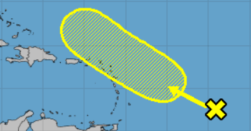
Only gradual development of this system is expected for the next few days while it moves west-northwestward across the northern Lesser Antilles.
- Formation chance through 48 hours…low…20 percent.
- Formation chance through 5 days…low…30 percent.
Well done, Forecaster Zelinsky.