
Now it’s Friday morning at 7:38. We’ve had two meaningful updates in the last 24 hours, both summarized below. When yesterday’s 2:00 p.m. update came out, we read every word at least twice, trying to get a feel for this “disturbance”. (By the way – that’s a great word for it – it really IS a disturbance to us. All plans are put on hold, or at least become very tentative, until this thing sorts itself out. Our lives are definitely disturbed right now.) We look at the image, somehow imagining that the path of the disturbance-that-might-become-a-storm is accurate down to the individual pixel – because that’s about how big we are in the image – a pixel.
We pay equal attention to the “probability” section, and we give it an equally inappropriate level of legitimacy. It can’t be that accurate – notice how the percentages are always in nice round numbers – 20%, 70%. It’s never 36%. Besides, we don’t even want it to be accurate half the time. If it’s a good number (0% and 10% are good numbers), we assume the forecaster is one of their best and brightest, and her numbers are spot-on. If it’s a bad number (70% and higher are definitely bad), we think “how can they possibly know? The guy was probably hungover when he came up with that”. We’re fickle that way.
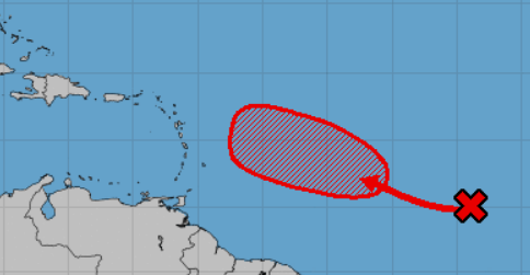
2:00 p.m. EDT, Thursday, August 1: A broad low pressure system located about 1100 miles west-southwest of the Cabo Verde Islands is producing limited shower and thunderstorm activity. Slow development of this system is expected during the next few days while it moves west-northwestward at 10 to 15 mph, and a tropical depression is likely to form several hundred miles east of the Lesser Antilles. Environmental conditions are now forecast to become unfavorable for additional development by early next week as the ystem approaches the Lesser Antilles.
- Formation chance through 48 hours…low…20 percent.
- Formation chance through 5 days…high…70 percent.
Fast-forward 12 hours, to 2:00 this morning. (Image and text below.) ORANGE! It’s ORANGE!!! That’s better than red, for sure! Yay, orange! And, dare I say it? The direction of that organge blob is DEFINITELY not pointed directly at us anymore! And the all-important forecaster’s comments: “less conducive for development”. We’re saved! And that 5 day percentage – only 50%, down from 70% just 12 hours earlier? Heck, we might as well stop worrying about this little ol’ thing. (But of course, we won’t. We’ll be hitting “refresh” on the NHC page today at 2:00 like a couple of lab rats waiting for the food pellet when we step on the right colored button.)
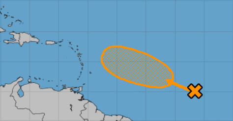
2:00 a.m. EDT Friday, Aug 2: An elongated low pressure blah blah blah Cabo Verde Islands blah blah Lesser Antilles limited shower blah blah slow development possible, a tropical depression could form blah blah forecast to become less conducive for development by Tuesday and Wednesday blah blah blah.
- Formation chance through 48 hours…low…20 percent.
- Formation chance through 5 days…medium…50 percent.
I hope it moves on and passes you by. btw, was it intentional that the favorable forecast was from “her” and the less favorable from “the guy”?
Yes, Jeff, we hope so too! (And yes, it was intentional. Trying to do my part.)